


Now taking on traffic jams across the US with its real time updates and maps, in Israel Waze has already proved it can shave precious minutes off your commute.
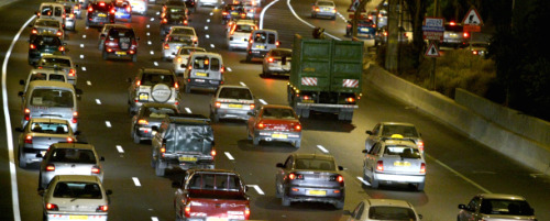
Israeli startup Waze may well have developed the technology to truly revolutionize driving, allowing drivers to shave precious minutes off their commutes, providing real time updates of traffic conditions, and even generating real-time maps – all for free.
Thanks to Waze, Israel has the most up-to-date traffic information of any Western country, says Waze founder and president Uri Levine. “We have a huge network of 200,000 (drivers) users in Israel, where we have been releasing our beta applications,” Levine tells ISRAEL21c, “and now we’ve begun taking on traffic jams in the US, coast to coast.”
In the two months that the Waze iPhone application has been available in the US, it has been downloaded by more than 50,000 people, many in the San Francisco area, where Waze has its US office.
Levine sees that number as just a drop in the bucket. “We expect hundreds of thousands, if not millions, of downloads as word gets out about Waze,” he asserts. And with traffic a daily challenge for most of us all over the world, Waze does not intend to restrict itself to the US.
As easy as GPS
To use Waze you simply download a version for your cell phone – iPhones, Android, Symbian devices, and Windows smartphones are currently supported – and install it. Once activated, the Waze software determines your location using GPS data (the vast majority of devices that can use Waze have built-in GPS trackers).
The program displays where you are on a map, and shows you the highways in the area. Notations displayed next to the roads tell you how congested the roads are, how long you can expect to be stuck in traffic, whether you’re near a speed trap, or whether there’s an accident tying up traffic on your route.
That information comes from drivers who form a temporary social networking community – both from active users who log into Waze and upload a traffic report, and passive drivers who do nothing but activate the program on their devices. And enabling those passive drivers is one of the things that makes Waze into such a useful program for all drivers, says Levine.
“With any interactive application, you have one percent of people who are very active, nine percent who are sometimes active, and 90% who are passive. Waze keeps track of driving patterns of drivers who are logged into the application via their GPS position, so we know what road they are on, how far they’ve driven, and how long it takes them to get where they’re going,” Levine explains.
The Waze application analyzes all the information it collects, and determines how much traffic there is on a particular road or if the route is clear. There’s no need to log in or otherwise submit personal information; simply by extrapolating your GPS position at regular intervals, the program can tell how far you’ve driven in a set amount of time and thus determine your average speed.
And when Waze compares your speed to the “normal” speed for the road you’re traveling on, Waze can figure out where the congestion is and how bad it is – and tell everyone else in the neighborhood to avoid that route.
Tapping into driver psychology
Even if they are passive members, drivers using Waze on the road form an ad-hoc community whose purpose is to help each other get to where they’re going. And like in any community, there are people who emerge as leaders. Waze has them covered, too.
“Active users report tie-ups, accidents and speed traps,” says Levine. “There are many drivers who feel a connection to others on the road and want to help them out, and there are others who just like to be first with important news. Those are the people we rely on to give reports on unusual incidents.”
In fact, says Levine, Waze taps deep into what he calls driver psychology. “Scientists have found that drivers on the road have allies and enemies – the former being the people behind you, and the latter the drivers ahead of you, especially when you feel they’re going too slow, or are driving recklessly. By giving a report of something you’ve seen, you help the people behind you – your allies – thus strengthening the community and making Waze an even more reliable tool,” he says.
The company is preparing to move into additional GPS-based information services. “Why not an application similar to Waze for bike riders, showing them routes, giving reports about bike path conditions, or for people who fish, indicating where the catches are?” Levine asks. “In addition, the current Waze application could be adapted to provide data on things of interest to drivers, like gas prices, parking conditions, etc.” he continues.
To that end, the company is preparing an API, which will in essence turn Waze from an application into a platform, enabling third parties to develop applications for Waze users.
From outwitting speed traps to changing the world
Ironically, Waze started life not as a traffic information application, but as a way to enable drivers to avoid speed traps. Years ago, one of Waze’s three co-founders, Ehud Shabtai (the other two are Levine and Amir Shinar) developed the speed-trap program for his iPaq PDA, and sent his program out for free to hundreds of users. The Israeli map provider ultimately forced him to pull the application and the updates, informing him that he was violating the service usage terms.
“But the genie was out of the bottle,” says Levine, and Shabtai, together with his partners, began exploring the use of GPS to develop accurate road map conditions, an idea that eventually morphed into an application called Freemap, and then into Waze.
The mapping aspect of the program itself, in fact, is as valuable as the traffic data, according to Levine. “It’s difficult to get up-to-date road maps, especially in Israel, and they are also very expensive here. Waze, based on the information collected from drivers, provides the most accurate maps possible, since they are updated in real time.”
While Levine could probably get some subscription money out of Waze users, he doesn’t plan to. “We intend to keep the application free for drivers, although we may end up selling sponsorships to advertisers, etc. We have a lot of ideas,” he says.
Of course, the money is important for the Waze team – but there are other, less tangible things that are important as well. “While I can’t say we wouldn’t entertain an offer from a multinational to buy us out, we’re in this for the long haul,” Levine relates. “With traffic such a problem all over the world, this can be one of the most important cell phone device applications ever developed. I wouldn’t mind seeing my name in the history books as someone who helped change the world,” he smiles.
More on Innovation


Fighting for Israel's truth
We cover what makes life in Israel so special — it's people. A non-profit organization, ISRAEL21c's team of journalists are committed to telling stories that humanize Israelis and show their positive impact on our world. You can bring these stories to life by making a donation of $6/month.